

Stories for you
- USYahoo News
Trump trial updates: Jury selection finished, man sets himself on fire outside courthouse
Five more alternate jurors were selected Friday following questioning from prosecution and defense lawyers, rounding out the 12 jurors and six alternates needed for the case against Trump to proceed.
2 min read - CelebrityYahoo Music
Taylor Swift drops Kim Kardashian dis track on 'The Tortured Poets Department.' Here's how 'thanK you aIMee' is reviving their feud.
Taylor Swift makes it clear on "The Tortured Poets Department" she's not over Kim Kardashian leaking
6 min read - EntertainmentYahoo Music
Quiz: 'The Tortured Poets Department' is out. So, how much do you know about Taylor Swift?
What’s her lucky number? How many Grammys has she won? What are the names of her cats? Find out how much you know about the pop star.
1 min read - NewsThe Yodel
Taylor Swift’s 'Tortured Poets Department' is a double album, Israel's airstrike in Iran and what to know about the NBA playoffs
The stories you need to start your day: Taylor Swift’s double album, Trump’s hush money trial latest and more in today’s edition of The Yodel newsletter
4 min read - News
Tesla recalls the Cybertruck for faulty accelerator pedals that can get stuck
Tesla is recalling all 3,878 Cybertrucks that it has shipped to date, due to a problem where the accelerator pedal can get stuck, putting drivers at risk of a crash, according to the National Highway Traffic Safety Administration.
- BusinessEngadget
Tesla is recalling Cybertrucks because their accelerator pedals could get stuck
Tesla has issued a recall for around 3,878 Cybertruck vehicles, a National Highway Traffic Safety Administration notice has revealed.
2 min read - USYahoo News
How the jury is being selected in Trump's hush money trial
Six alternates still need to be chosen before opening arguments in the case against the former president can begin.
2 min read - BusinessYahoo Finance
Stock market today: US futures dig out of Israel strike-fueled tumble
A measure of calm was returning after Israel's retaliatory strike on Iran spooked the market and spurred a rush to safe havens such as gold.
2 min read - CelebrityNY Daily News
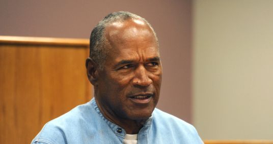
OJ Simpson did not die surrounded by loved ones, says lawyer
The family of O.J. Simpson announced last week the former football star died on April 10 “surrounded by his children and grandchildren.” But according to Simpson’s longtime lawyer Malcolm LaVergne, the 76-year-old father of four was a sole visitor away from dying alone. LaVergne declined to tell The Associated Press who was at Simpson’s bedside when the acquitted double-murder defendant ...
2 min read - HealthYahoo Life
Is calorie intake or time-restricted eating more important for weight loss? Here's what a new study says.
Does when you eat matter when it comes to losing weight? Here's what one new study found.
4 min read - HealthYahoo Life
Signs of multiple sclerosis can be detected in blood 5 years before symptoms appear, new study finds. Here's why this breakthrough is important.
What you need to know about the study, as well as who is most at risk for multiple sclerosis and early signs to look out for.
5 min read - LifestyleYahoo Life Shopping
We review hundreds of products a month. Here are the 10 absolute best our editors tested this week.
These 10 winners wowed our team of experts and came out as the top of the crop in each of their categories.
1 min read - LifestyleYahoo Life Shopping
25 of the very best hostess gifts that'll guarantee you an invite back
Bring one of these finds from Nordstrom, Anthropologie or Amazon to your next soirée.
2 min read - EntertainmentYahoo Music
Taylor Swift asks 'who else decodes you?' on 'The Tortured Poets Department.' What to know about the 'secret double album.'
Taylor Swift has been dropping easter eggs like crazy about "The Tortured Poets Department." Here's everything we know about her new album, including its first single, "Fortnight."
8 min read - StyleYahoo Life Shopping
The best brow gel of 2024 will make even the thinnest arches look robust and refined
Sparse brows? Our top picks define, shape and bring new life to to your strands
4 min read - BusinessYahoo Finance
One of Wall Street's favorite calls to start 2024 has flopped
Wall Street strategists are becoming less confident in small cap stocks as Fed rate cut hopes diminish.
4 min read - SportsEngadget
The best PS5 games for 2024: Top PlayStation titles to play right now
Here are the best games you can get for the PlayStation 5 right now, as chosen by Engadget editors.
1 min read - PoliticsSlate
George Santos Just Had to Admit How Much Money He Owes People. Oh Boy.
“Obviously, the circumstances here are a little extenuating,” Santos said.
9 min read - LifestyleYahoo Life Shopping
The 10 best deodorants and antiperspirants for women of 2024, according to dermatologists and testers
From Secret to Kopari, Megababe and Mitchum, these are the best deodorants for women, tested and dermatologist-approved.
9 min read - LifestyleThe Kitchn
The $5 Aldi Frozen Dinner Find Shoppers “Have Been Waiting” For All Year
Shoppers are raving about how good it is!
2 min read - BusinessYahoo Personal Finance
Mortgage rates today, April 19, 2024: Rates up for third straight week
These are today's mortgage rates. The 30-year and 15-year fixed are up for the third week in a row. Lock in your rate today.
4 min read - TechnologyYahoo Tech
The 7 best tablets of 2024: Apple, Acer, Amazon Fire and more
Best Android screen machine? Best iPad? Find the perfect gadget for your specific needs.
6 min read - StyleYahoo Life Shopping
These are the best Hoka shoes for walking in 2024
Looking for a little extra cushioning while you get your steps in? You've come to the right place.
4 min read - BusinessAutoblog
GM is moving out of its Detroit headquarters towers
Something's happening with General Motors' headquarters buildings, and it may mean they'll no longer be GM's headquarters buildings.
4 min read - BusinessFortune
The economy might be booming, but housing is in a recession: Top real estate CEO says he’s never seen anything like it in 20 years
Redfin’s Glenn Kelman discusses his business, salary, and all things housing with Fortune.
7 min read - SportsYahoo Sports
Lions revived alternate black jerseys for Dan Campbell on 1 condition
The Detroit Lions revealed their new uniforms, which include a black jersey that head coach Dan Campell wanted the team to revive.
2 min read - SportsYahoo Sports
Jaromír Jágr scores in first game since turning 52, passes Gordie Howe as oldest professional hockey player
Jágr began his NHL career in 1990 with the Pittsburgh Penguins.
2 min read - SportsYahoo Sports
Rangers' Jack Leiter strikes out first batter he faces but gets roughed up by Tigers in historic MLB debut
Leiter lasted 3 2/3 innings in his MLB debut for the Rangers.
2 min read - SportsYahoo Sports
AJ Simon, Albany defensive standout and NFL Draft prospect, dies at 25
Simon had visited with the Patriots ahead of next week's NFL draft.
1 min read - SportsYahoo Sports
NBA playoffs: Predictions for Knicks-Sixers, Nuggets-Lakers and every first-round series
Our NBA experts make their predictions for every first-round series in the playoffs.
1 min read - SportsYahoo Sports
Pirates LHP Aroldis Chapman suspended 2 games for argument with umpire after ejection
Chapman signed a $10.5 million deal with the Pirates this past offseason.
2 min read - SportsYahoo Sports
Ex-Braves player Gary Cooper petitioning for 'just one day' back in majors to qualify for pension
Cooper, now 67, spent 42 days with the Braves in 1980, falling one day short of the minimum.
4 min read - SportsYahoo Sports
Ravens WR Zay Flowers avoids suspension after NFL finds 'insufficient evidence' from domestic assault investigation
Baltimore police suspended their investigation into Flowers two months ago.
2 min read - SportsYahoo Sports
Fantasy Baseball Waiver Wire: Pickups to wrap up Week 3
Fantasy baseball analyst Andy Behrens offers up a series of pickups to assist every manager, starting with a duo of Rockies ahead of a Colorado homestand.
4 min read - CelebrityYahoo Canada Style
Canadian influencer Sarah DeMelo says 'cancer really does change your life' as she marks 1 year since diagnosis
A year after her cancer diagnosis, Sarah DeMelo has a "whole new outlook" on life, she says.
3 min read - SportsYahoo Sports
Safety C.J. Moore among 5 NFL players reinstated after being suspended for gambling
Former Detroit Lions safety C.J. Moore is one of five players reinstated by the NFL after serving a one-season suspension for violating the league's gambling policy.
2 min read - SportsYahoo Sports
2024 NFL Draft: Watch out, vets — the seasoned players who could be pushed out of the way by rookies
Fantasy football players all get worked up about the incoming class of rookies, but what about the veteran players already on the teams they join? Matt Harmon identifies who could be on the hot seat this season.
12 min read - EntertainmentEngadget
Ryan Gosling and Miller/Lord’s Project Hail Mary could be the sci-fi event of 2026
Amazon MGM just set a March 20, 2026 release date for Project Hail Mary, an adaptation of the Andy Weir novel. The film stars Ryan Gosling and is directed by Phil Lord and Christopher Miller.
2 min read - SportsDevils Illustrated
TJ Power entering transfer portal
Duke forward leaving after one season TJ Power takes a shot during a game this past season. Rob Kinnan/USA Today Sports Images TJ Power will be the eighth player to leave Duke via transfer portal or the NBA draft.
1 min read - SportsYahoo Sports
Red Sox reportedly calling up Cam Booser, 31-year-old pitcher, for MLB debut
The Boston Red Sox are calling up 31-year-old reliever Cam Booser, who has never pitched in the major leagues and was out of professional baseball for four years.
2 min read - PoliticsYahoo News
Trump trial update: Trump rebuked by judge for speaking during jury selection — and 7 jurors are seated
On Tuesday, the second day of former President Donald Trump’s hush money trial, Judge Juan Merchan rebuked defense lawyers after Trump was heard muttering his disapproval of an answer given by a potential juror in the case.
2 min read - SportsYahoo Sports
UConn freshman guard Stephon Castle declares for 2024 NBA Draft
Castle is the third member of the 2023-24 Huskies to declare for the NBA Draft.
1 min read - SportsYahoo Sports
NBA playoffs: Who will meet in the Finals? Who has the most at stake this postseason? We break it all down
Who is the biggest threat to the Celtics in the East? The Nuggets in the West? And which team will be crowned champion? Our writers weigh in.
14 min read - SportsYahoo Sports
Knicks-76ers preview: Is New York the favorite against Philadelphia and Joel Embiid?
We break down the first-round matchup between the New York Knicks and Philadelphia 76ers and make our prediction.
9 min read - LifestyleYahoo Life Shopping
'Almost all my flaws disappeared': 19,000+ shoppers love this $20 Laura Geller powder, on rare sale
Fans say it's especially great on mature skin: 'The benefits of color-correcting makeup can't be overstated.'
4 min read - LifestyleAutoblog
2024 Toyota Land Cruiser Review: Cool, capable, family friendly, perhaps too pricey
Everything we know about the all-new 2024 Toyota Land Cruiser, including its price, fuel economy, hybrid power specs and more.
9 min read - SportsYahoo Sports
Ex-USC coach Tony Bland reportedly returns to college basketball with Washington after bribery conviction
Bland pleaded guilty to conspiracy to commit bribery in 2019.
2 min read - SportsYahoo Sports
Jaden Rashada announces transfer from Arizona State, 1 year after landing there in wake of Florida NIL fiasco
Jaden Rashada's college career has been a wild ride so far.
2 min read - SportsInside Nebraska
Tony White doubles down on goal of NU forming "best defense in the country"
Tony White lists spring standouts at each level of NU defense, doubles down on wanting "best defense in the country."
1 min read - EntertainmentYahoo Entertainment
Travis Kelce takes on new role as host of 'Are You Smarter Than a Celebrity?' He joins a roster of athletes helming game shows.
The Kansas City Chiefs tight end joins the popular spin-off series that will air on Prime Video.
6 min read - SportsHawgBeat
Kenny Payne set to join Arkansas coaching staff
Arkansas has officially hired Kenny Payne as an assistant basketball coach under head coach John Calipari.
1 min read - BusinessYahoo Finance
Jay Powell just made buying a home this spring even more challenging
The Fed chair this week doused any hopes home buyers still had that mortgage rates would soften anytime soon. That has big implications for the housing market.
4 min read - SportsRivals
Texas A's DFW success continues with pledge of Connor Carty
Prosper (Texas) offensive guard Connor Carty, 6-foot-5, 295-pounds, announced his commitment to the Aggies on Thursday.
2 min read - SportsYahoo Sports
Deion Sanders denies he made list of NFL teams he'd let his kids play for: 'That's a stupid lie'
Sanders supposedly said he'd only let Shedeur and Shilo play for the Eagles, Falcons, 49ers, Commanders, Cowboys and Ravens. That appears to be false.
5 min read - SportsYahoo Sports
Rockies hitting coach Hensley Meulens' cockpit visit triggers FAA investigation
Meulens is seen in a since-deleted video sitting in one of the pilots' seats during a team charter from Denver to Toronto.
1 min read - OpinionThe New Republic
Trump Finally Sees Consequences for his Big Mouth in Hush-Money Trial
Judge Juan Merchan penalized the former president and his legal team.
1 min read - PoliticsSnopes
Fact Check: People Are Claiming Trump Never Attended His Children's Graduations. Here's What We Found
The former president's complaint that he might be unable to attend his son Barron's high school graduation due to his trial spawned misinformation.
8 min read - USAssociated Press
Emergency rooms refused to treat pregnant women, leaving one to miscarry in a lobby restroom
One woman miscarried in the lobby restroom of a Texas emergency room as front desk staff refused to admit her. Another woman learned that her fetus had no heartbeat at a Florida hospital, the day after a security guard turned her away from the facility. Complaints that pregnant women were turned away from U.S. emergency rooms spiked in 2022 after the U.S. Supreme Court overturned Roe v. Wade, federal documents obtained by The Associated Press reveal.
8 min read - PoliticsHuffPost
Ex-Trump Aide Details How Staffers Would Keep Former President Awake
One-time "Apprentice" contestant Omarosa Manigault Newman also predicted a Trump outburst in his hush money trial.
1 min read - BusinessCNN Business
Aldi’s ‘aisle of shame’ is a middle row of goodies that have nothing to do with groceries. Shoppers are huge fans of it
Caitlyn Pratt is an avid Aldi shopper, so much so that she crosses state lines a few times a month to drive 45 minutes to the nearest one in neighboring Arkanas.
8 min read - CelebrityConsequence of Sound
Taylor Swift Releases Kim Kardashian Diss Track “thanK you aIMee”
The diss track appears on the surprise second half of Swift's new album, The Tortured Poets Department. Taylor Swift Releases Kim Kardashian Diss Track “thanK you aIMee” Scoop Harrison
3 min read - EntertainmentGood Morning America
'American Idol' alum and Grammy winner Mandisa dies at 47
Mandisa, who competed on season 5 of "American Idol" and went on to become a successful Christian recording artist, has died. A rep for the singer confirmed to ABC News that Mandisa was found dead in her home on April 18. Mandisa, born Mandisa Lynn Hundley, finished ninth on the "American Idol" season that was won by Taylor Hicks and also gave us Katharine McPhee, Chris Daughtry and Kellie Pickler.
2 min read - CelebrityGood Morning America
Savannah Chrisley on hope for parents' future, raising teen brother and niece
Savannah Chrisley is opening up about her life after her parents Todd and Julie Chrisley's imprisonment, and sharing her hope for their future. The couple, who became famous for their show "Chrisley Knows Best," were sentenced in November 2022 to a combined 19 years in prison on charges including fraud and tax evasion. Todd was sentenced to 12 years in prison and 16 months of probation while Julie was ordered to serve seven years in prison and 16 months of probation.
2 min read - WorldPeople
Why Queen Letizia of Spain Sat to Greet Guests in Her Ballgown at State Banquet in the Netherlands
The Queen of Spain had a relatable reason for saying hello while sitting down
5 min read - USKARK
Court releases details of Little Rock’s Immanuel Baptist Church volunteer’s alleged sexual assault, investigation
Details of an alleged sexual assault that took place between a student and volunteer associated with Little Rock’s Immanuel Baptist Church were released by the court on Wednesday.
2 min read - CelebritySheKnows
Kim Kardashian Reveals Kourtney Kardashian’s Postpartum Body in Birthday Tribute & It’s Causing a Firestorm in the Comments
Like all sisters, Kim Kardashian and Kourtney Kardashian have had their disagreements. But unlike all sisters, the Kardashian sisters’ notorious feuds are very public. Especially on the last season of The Kardashians. Lots of fans trace the fight back to Kourtney’s wedding to Travis Barker in 2022. The Lemme founder partnered with Dolce & Gabbana …
3 min read - PoliticsCNN
Trump campaign and RNC pledge to unleash thousands to monitor vote counting in battleground states
The Trump campaign and Republican National Committee are pledging to deploy 100,000 volunteers and lawyers to monitor vote counting across battleground states this year – part of what officials describe as a stepped-up focus on “election integrity” by the national party.
2 min read - USCNN
Maryland high school student arrested after authorities discovered a 129-page document detailing school shooting plan, police say
A Maryland high school student was arrested and charged with threat of mass violence after police say they discovered evidence revealing the teen had plans to commit a school shooting, authorities said Thursday.
3 min read - OpinionCNN
Opinion: I survived the Holocaust. What I see happening in Berkeley is frightening
Holocaust survivor Susanne DeWitt reflects on the spike in antisemitism in Berkeley, California — her home of over six decades, and now, a place where Jewish hate has gone unchallenged in public forums, public schools and businesses.
3 min read - USKTVU
3 people arrested in kidnap, torture case in San Jose: police
San Jose police announce the arrest of three people accused in a kidnap and torture case. Investigators said one of the alleged kidnappers was also identified as the "primary suspect" in a major retail theft ring.
3 min read - SportsCNN
Kyrie Irving says he ‘grew up in a time’ when you had to try out for USA Basketball after omission from Paris 2024
Dallas Mavericks star Kyrie Irving said he “just didn’t fit” into the 12-man basketball roster selected to represent Team USA at the upcoming Olympic Games.
2 min read - USUSA TODAY
'I tried telling them to stop': Video shows people yank bear cubs from tree for selfie
The incident was captured by a resident of the Asheville apartment complex. One bear cub was found "a bit traumatized." The other cub was not located.
5 min read - OpinionUSA TODAY Opinion
Tom Cotton, Kari Lake show how much Trump, Republicans have normalized violent rhetoric
Republicans Kari Lake and Sen. Tom Cotton both spouted outrageous violent rhetoric this week, and nobody seems to care. Americans deserve better.
5 min read - PoliticsThe Daily Beast
Fox News Anchor Reminds GOP Senator That Trump Killed His Border Deal
Fox NewsSen. James Lankford (R-OK), the GOP co-architect of the Senate’s failed immigration bill earlier this year, made what were perhaps his most critical comments yet on Donald Trump’s role in scuttling the legislation, alluding to Fox News Thursday that the former president was motivated by his political self-interest.On Your World, Lankford was confronted by anchor Neil Cavuto about the players behind the bill’s demise.“You are a real gentleman about this, and I know you’re not trying to zi
2 min read - USHuffPost
Trump's Chilling New Courthouse Rant Gets Put On Ice By Critics
The former president's latest complaint gets a cool reception on social media.
2 min read - USUSA TODAY
'Cowardly judge:' Dismissed Trump hush money trial juror number 4 shares his story: Exclusive
Herson Cabreras said he was taken aback when prosecutors moved to oust him from the jury in Donald Trump's criminal trial.
4 min read - USKTLA articles
Bouncer at West Hollywood nightclub arrested after violent altercation
A bouncer at a popular West Hollywood nightclub has been arrested nearly two weeks after allegedly punching a person who was trying to get into the bar in the face so violently that they suffered severe head trauma. The incident, according to the Los Angeles County Sheriff’s Department, occurred on April 5 at around […]
3 min read - USKTVI
Cleaning up from storm damage across the St. Louis region
ST. LOUIS — Severe storms on Thursday evening caused significant damage across the St. Louis region. A suspected tornado in Prairietown, Illinois destroyed a farm that had been there for nearly a century. The storm also left behind damaged tree limbs and downed power lines in the area. Fortunately, no injuries were reported, as no […]
1 min read - LifestyleINSIDER
I raised my son in Germany until he was 6. Now, we're back in the US, and my family is going through reverse culture shock.
As an American mom raising her son in Berlin, the author rarely saw parents correcting bad behavior. Now, living in New York, she's surprised by how many rules are enforced.
5 min read